-
#import "ViewController.h"
- #import "MKMapView+ZoomLevel.h"
-
- @interface ViewController ()
-
- @end
-
- @implementation ViewController
-
- @synthesize myMapView;
-
@synthesize myLocationManager;
- @synthesize myGeoCoder;
-
- (void)viewDidLoad
- {
-
[super viewDidLoad];
-
// Do any additional setup after loading the view, typically from a nib.
-
// 设置根View的背景颜色
- self.view.backgroundColor = [UIColor colorWithRed:0x33 / 255.0f green:0x66 / 255.0f blue:0x99 / 255.0f alpha:0xFF / 255.0f];
-
// 初始化MapView并且设置MapView显示的边界
- self.myMapView = [[MKMapView alloc]initWithFrame:self.view.bounds];
-
// self.myMapView.mapType = MKMapTypeSatellite;
- // self.myMapView.mapType = MKMapTypeHybrid;
-
self.myMapView.mapType = MKMapTypeStandard;
- self.myMapView.autoresizingMask = UIViewAutoresizingFlexibleWidth | UIViewAutoresizingFlexibleHeight;
-
self.myMapView.delegate = self;
-
-
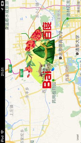
CLLocationCoordinate2D coordinate = CLLocationCoordinate2DMake(40.034122, 116.289574);
- MyAnnotation *annotation = [[MyAnnotation alloc]initWithCoordinate:coordinate title:@"我的位置" subTitle:@"这里就是寡人的位置,嘿嘿!"];
-
annotation.pinColor = MKPinAnnotationColorPurple;
-
-
[self.myMapView addAnnotation:annotation];
-
-
- [self.myMapView setShowsUserLocation:YES];
-
[self.myMapView setCenterCoordinate:coordinate zoomLevel:15 animated:YES];
-
-
[self.view addSubview:myMapView];
-
-
- if([CLLocationManager locationServicesEnabled]){
-
self.myLocatiOnManager= [[CLLocationManager alloc]init];
- self.myLocationManager.delegate = self;
-
// // 提示用户是否允许当前应用使用地理位置,已过时,在Info.plist中使用NSLocationUsageDescription键值替换
- // self.myLocationManager.purpose = @"提示用户是否允许当前应用使用位置,已过时";
-
[self.myLocationManager startUpdatingLocation];
- }else{
-
NSLog(@">>>>>>>>>> 位置服务不可用 <<<<<<<<<<<<");
- UIAlertView *alertView = [[UIAlertView alloc] initWithTitle:@"提示" message:@"您的位置服务当前不可用,请打开位置服务后重试" delegate:nil cancelButtonTitle:@"确定" otherButtonTitles:nil, nil];
-
[alertView show];
- }
-
-
-
CLLocation *location = [[CLLocation alloc]initWithLatitude:40.034122 longitude:116.289574];
-
-
self.myGeoCoder = [[CLGeocoder alloc]init];
- [self.myGeoCoder reverseGeocodeLocation:location completionHandler:^(NSArray *placemarks,NSError *error){
-
if(error == nil && [placemarks count] > 0){
- CLPlacemark *pm = [placemarks objectAtIndex:0];
-
NSLog(@"国家:%@" ,pm.country);
- NSLog(@"邮编:%@",pm.postalCode);
-
NSLog(@"Locality:%@",pm.locality);
- }else if(error == nil && [placemarks count] == 0){
-
NSLog(@"没有地址返回");
- }else if(error != nil){
-
NSLog(@"出错了:%@",error);
- }
-
}];
-
-
[self.myGeoCoder geocodeAddressString:@"中国北京市海淀区花园东路10号高德大厦" completionHandler:^(NSArray *placemarks,NSError *error){
- if(nil == error && [placemarks count] > 0){
-
NSLog(@"placemarks count:%i",[placemarks count]);
- CLPlacemark *pm = [placemarks objectAtIndex:0];
-
NSLog(@"lOngitude=%f",pm.location.coordinate.longitude);
- NSLog(@"latitude=%f",pm.location.coordinate.latitude);
-
}else if([placemarks count] == 0 && error == nil){
- NSLog(@"找不到给定地址的经纬度");
-
}else if(nil != nil){
- NSLog(@"发生了错误:%@",error);
-
}
- }];
-
-
-
-
-
- }
-
- - (void)didReceiveMemoryWarning
-
{
- [super didReceiveMemoryWarning];
-
// Dispose of any resources that can be recreated.
-
-
}
- -(void)viewDidUnload
-
{
- [super viewDidUnload];
-
self.myMapView = nil;
- [self.myLocationManager stopUpdatingLocation];
-
self.myLocatiOnManager= nil;
- }
-
-(BOOL)shouldAutorotateToInterfaceOrientation:(UIInterfaceOrientation)toInterfaceOrientation
- {
-
return YES;
- }
-
-
-
/*******************************************************************************************/
- /*******************************************************************************************/
-
/*************************** MapView的Delegate的方法,全部都是Option的 *************************/
- /*******************************************************************************************/
-
/*******************************************************************************************/
- /*******************************************************************************************/
-
- - (void)mapView:(MKMapView *)mapView regionWillChangeAnimated:(BOOL)animated {
-
NSLog(@"mapView:regionWillChangeAnimated:方法被调用");
- }
-
// 用户的地理位置发生改变的时候调用
- - (void)mapView:(MKMapView *)mapView regionDidChangeAnimated:(BOOL)animated {
-
NSLog(@"mapView:regionDidChangeAnimated:方法被调用");
- }
-
// 当地图界面将要加载的时候将会调用这个方法
- - (void)mapViewWillStartLoadingMap:(MKMapView *)mapView{
-
NSLog(@"mapViewWillStartLoadingMap:方法被调用");
- }
-
// 当地图界面加载完成的时候将要调用这个方法
- - (void)mapViewDidFinishLoadingMap:(MKMapView *)mapView{
-
NSLog(@"mapViewDidFinishLoadingMap:方法被调用");
- }
-
// 当地图界面加载失败的时候调用这个方法
- - (void)mapViewDidFailLoadingMap:(MKMapView *)mapView withError:(NSError *)error{
-
NSLog(@"mapViewDidFailLoadingMap:withError:方法被调用,error is:%@" , [error description]);
- }
-
// 添加到地图的Annotation
- // mapView:viewForAnnotation: provides the view for each annotation.
-
// This method may be called for all or some of the added annotations.
- // For MapKit provided annotations (eg. MKUserLocation) return nil to use the MapKit provided annotation view.
-
- (MKAnnotationView *)mapView:(MKMapView *)mapView viewForAnnotation:(id )annotation
- {
-
MKAnnotationView *view = nil;
- if([annotation isKindOfClass:[MyAnnotation class]] == NO){
-
return view;
- }
-
if([mapView isEqual:self.myMapView] == NO){
- return view;
-
}
-
-
MyAnnotation *senderAnnotation = (MyAnnotation*)annotation;
- NSString *pinReusableIdentifier = [MyAnnotation reusableIdentifierForPinColor:senderAnnotation.pinColor];
-
MKPinAnnotationView *annotatiOnView= (MKPinAnnotationView*)[mapView dequeueReusableAnnotationViewWithIdentifier:pinReusableIdentifier];
- if(annotatiOnView== nil){
-
annotatiOnView= [[MKPinAnnotationView alloc]initWithAnnotation:senderAnnotation reuseIdentifier:pinReusableIdentifier];
- [annotationView setCanShowCallout:YES];
-
}
- annotationView.pinColor = senderAnnotation.pinColor;
-
-
-
NSArray *paths = NSSearchPathForDirectoriesInDomains(NSDocumentDirectory, NSUserDomainMask, YES);
- NSString *documentPath = [paths objectAtIndex:0];
-
-
-
NSString *cachePath = [documentPath stringByAppendingString:@"/images"];
- NSString *cacheFile = [cachePath stringByAppendingString:@"icon.image"];
-
- if([[NSFileManager defaultManager]fileExistsAtPath:cacheFile]){
-
UIImage *image = [UIImage imageWithContentsOfFile:cacheFile];
- if(image != nil){
-
annotationView.image = image;
- NSLog(@"通过本地设置图片");
-
}else{
- [self setAnnotionImageByUrl:annotationView cacheFile:cacheFile];
-
}
- }else{
-
[self setAnnotionImageByUrl:annotationView cacheFile:cacheFile];
- }
-
view = annotationView;
-
-
return view;
- }
-
- -(void) setAnnotionImageByUrl:(MKPinAnnotationView *)annotationView cacheFile:(NSString *) cacheFile{
-
NSLog(@"通过网络设置文件");
- dispatch_queue_t queue = dispatch_get_global_queue(DISPATCH_QUEUE_PRIORITY_DEFAULT, 0);
-
dispatch_async(queue, ^{
-
-
-
-
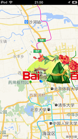
NSURL *url = [NSURL URLWithString:@"http://www.baidu.com/img/duanwulogo_94a0060bda0885d1c2320ca0d7d7c342.gif"];
- NSData *data = [NSData dataWithContentsOfURL:url];
-
- if(data != nil){
-
- [data writeToFile:cacheFile atomically:YES];
-
- UIImage *image = [UIImage imageWithData:data];
-
dispatch_queue_t mainQueue = dispatch_get_main_queue();
- dispatch_async(mainQueue, ^{
-
if(image != nil){
- annotationView.image = image;
-
}
- });
-
}
- });
-
- }
-
- /**
-
- // mapView:didAddAnnotationViews: is called after the annotation views have been added and positioned in the map.
-
// The delegate can implement this method to animate the adding of the annotations views.
- // Use the current positions of the annotation views as the destinations of the animation.
-
- (void)mapView:(MKMapView *)mapView didAddAnnotationViews:(NSArray *)views;
-
-
// mapView:annotationView:calloutAccessoryControlTapped: is called when the user taps on left & right callout accessory UIControls.
- - (void)mapView:(MKMapView *)mapView annotationView:(MKAnnotationView *)view calloutAccessoryControlTapped:(UIControl *)control;
-
- - (void)mapView:(MKMapView *)mapView didSelectAnnotationView:(MKAnnotationView *)view NS_AVAILABLE(NA, 4_0);
-
- (void)mapView:(MKMapView *)mapView didDeselectAnnotationView:(MKAnnotationView *)view NS_AVAILABLE(NA, 4_0);
-
-
- (void)mapViewWillStartLocatingUser:(MKMapView *)mapView NS_AVAILABLE(NA, 4_0);
- - (void)mapViewDidStopLocatingUser:(MKMapView *)mapView NS_AVAILABLE(NA, 4_0);
-
- (void)mapView:(MKMapView *)mapView didUpdateUserLocation:(MKUserLocation *)userLocation NS_AVAILABLE(NA, 4_0);
- - (void)mapView:(MKMapView *)mapView didFailToLocateUserWithError:(NSError *)error NS_AVAILABLE(NA, 4_0);
-
- - (void)mapView:(MKMapView *)mapView annotationView:(MKAnnotationView *)view didChangeDragState:(MKAnnotationViewDragState)newState
-
fromOldState:(MKAnnotationViewDragState)oldState NS_AVAILABLE(NA, 4_0);
-
-
- (MKOverlayView *)mapView:(MKMapView *)mapView viewForOverlay:(id )overlay NS_AVAILABLE(NA, 4_0);
-
-
// Called after the provided overlay views have been added and positioned in the map.
- - (void)mapView:(MKMapView *)mapView didAddOverlayViews:(NSArray *)overlayViews NS_AVAILABLE(NA, 4_0);
-
- - (void)mapView:(MKMapView *)mapView didChangeUserTrackingMode:(MKUserTrackingMode)mode animated:(BOOL)animated NS_AVAILABLE(NA, 5_0);
-
*/
-
-
-
-
- /*******************************************************************************************/
-
/*******************************************************************************************/
- /*************************** 位置相关 *************************/
-
/*******************************************************************************************/
- /*******************************************************************************************/
-
/*******************************************************************************************/
-
-
-(void)locationManager:(CLLocationManager *)manager didUpdateToLocation:(CLLocation *)newLocation fromLocation:(CLLocation *)oldLocation
- {
-
NSLog(@"Latitude=%f",newLocation.coordinate.latitude);
- NSLog(@"LOngitude=%f",newLocation.coordinate.longitude);
-
}
- -(void)locationManager:(CLLocationManager *)manager didFailWithError:(NSError *)error
-
{
-
-
NSLog(@"获得位置失败");
- }
-
- @end
-
#import "MKMapView+ZoomLevel.h"
-
-
@implementation MKMapView (ZoomLevel)
- #define MERCATOR_OFFSET 268435456
-
#define MERCATOR_RADIUS 85445659.44705395
-
-
#pragma mark -
- #pragma mark Map conversion methods
-
- - (double)longitudeToPixelSpaceX:(double)longitude
-
{
- return round(MERCATOR_OFFSET + MERCATOR_RADIUS * longitude * M_PI / 180.0);
-
}
-
-
- (double)latitudeToPixelSpaceY:(double)latitude
- {
-
return round(MERCATOR_OFFSET - MERCATOR_RADIUS * logf((1 + sinf(latitude * M_PI / 180.0)) / (1 - sinf(latitude * M_PI / 180.0))) / 2.0);
- }
-
- - (double)pixelSpaceXToLongitude:(double)pixelX
-
{
- return ((round(pixelX) - MERCATOR_OFFSET) / MERCATOR_RADIUS) * 180.0 / M_PI;
-
}
-
-
- (double)pixelSpaceYToLatitude:(double)pixelY
- {
-
return (M_PI / 2.0 - 2.0 * atan(exp((round(pixelY) - MERCATOR_OFFSET) / MERCATOR_RADIUS))) * 180.0 / M_PI;
- }
-
- #pragma mark -
-
#pragma mark Helper methods
-
-
- (MKCoordinateSpan)coordinateSpanWithMapView:(MKMapView *)mapView
- centerCoordinate:(CLLocationCoordinate2D)centerCoordinate
-
andZoomLevel:(NSUInteger)zoomLevel
- {
-
// convert center coordiate to pixel space
- double centerPixelX = [self longitudeToPixelSpaceX:centerCoordinate.longitude];
-
double centerPixelY = [self latitudeToPixelSpaceY:centerCoordinate.latitude];
-
-
// determine the scale value from the zoom level
- NSInteger zoomExpOnent= 20 - zoomLevel;
-
double zoomScale = pow(2, zoomExponent);
-
-
// scale the map's size in pixel space
- CGSize mapSizeInPixels = mapView.bounds.size;
-
double scaledMapWidth = mapSizeInPixels.width * zoomScale;
- double scaledMapHeight = mapSizeInPixels.height * zoomScale;
-
-
// figure out the position of the top-left pixel
-
double topLeftPixelX = centerPixelX - (scaledMapWidth / 2);
- double topLeftPixelY = centerPixelY - (scaledMapHeight / 2);
-
-
// find delta between left and right longitudes
-
CLLocationDegrees minLng = [self pixelSpaceXToLongitude:topLeftPixelX];
- CLLocationDegrees maxLng = [self pixelSpaceXToLongitude:topLeftPixelX + scaledMapWidth];
-
CLLocationDegrees lOngitudeDelta= maxLng - minLng;
-
-
// find delta between top and bottom latitudes
- CLLocationDegrees minLat = [self pixelSpaceYToLatitude:topLeftPixelY];
-
CLLocationDegrees maxLat = [self pixelSpaceYToLatitude:topLeftPixelY + scaledMapHeight];
- CLLocationDegrees latitudeDelta = -1 * (maxLat - minLat);
-
-
// create and return the lat/lng span
-
MKCoordinateSpan span = MKCoordinateSpanMake(latitudeDelta, longitudeDelta);
- return span;
-
}
-
-
#pragma mark -
- #pragma mark Public methods
-
- - (void)setCenterCoordinate:(CLLocationCoordinate2D)centerCoordinate
-
zoomLevel:(NSUInteger)zoomLevel
- animated:(BOOL)animated
-
{
-
// clamp large numbers to 28
-
zoomLevel = MIN(zoomLevel, 28);
-
-
// use the zoom level to compute the region
- MKCoordinateSpan span = [self coordinateSpanWithMapView:self centerCoordinate:centerCoordinate andZoomLevel:zoomLevel];
-
MKCoordinateRegion region = MKCoordinateRegionMake(centerCoordinate, span);
-
-
// set the region like normal
- [self setRegion:region animated:animated];
-
}
-
-
- @end


 京公网安备 11010802041100号 | 京ICP备19059560号-4 | PHP1.CN 第一PHP社区 版权所有